Google recently released an update to Earth ('Terra', in Spanish), the company's program that is available for desktop and mobile platforms and allows you to view various places in the world and visit the main tourist attractions, such as the Eiffel Tower, Louvre or even visit the interior of the White House, home of the President of the United States. In addition to all these features, the developer this week added a time-lapse function that allows you to follow the evolution of various biomes and regions, such as the Amazon rainforest.
The content has been divided into a few themes and can be accessed through forest change, urban growth, warming temperatures, energy sources.
historical time-lapse
The novelty allows the user to see a quick time-lapse of the changes that took place in a certain place, such as the creation of cities or the modernization of a region, and it is also possible to visualize the impact of climate change. of the captures made by the satellites and grouped in order to form a history that can be navigated according to the year in question.
The content is available for free and in 2D or 3D formats, and you can even download videos. To access this new function, you must have the latest version of the software installed or use the browser version, which consumes a lot of RAM memory.
- Download Google Earth for PC (Windows, MAC and Linux);
- Download Google Earth for Android.
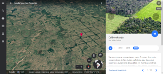
These new 3D additions not only show the dimensional scale in some cases, but also provide a more immersive experience. It is possible to watch a glacier retreat over four decades or see the vegetation of the Amazon rainforest giving way to roads.
Read also:
- Android 12: Which phones will get the update in 2022?
- Best browsers to use on PC in 2022
Image source
The company said the data used to create these videos is compiled from "more than 24 million satellite images from 1984 to 2020," Moore wrote. Google worked with NASA, the US Geological Survey and the European Space Agency (ESA) Copernicus program to use imagery from its Landsat and Sentinel satellites for the project and generate the content that was input from the last update.
In addition to the new form of entertainment generated from time-lapse images, Google also reported that the project aims to help researchers and scientists understand the effects of climate change, deforestation and other phenomena on the planet.
Oppo Watch and Band Style get iOS support
Source