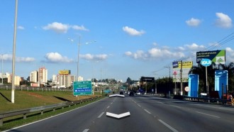
Google announced today on its blog that it has started allowing people to take pictures with their smartphones to upload images to Street View, a feature of the Google Maps app that is used to see in detail what is in certain locations. Now you no longer need a special camera that takes 360° photos or a backpack with a stick and a camera on top or even a car with a camera on top, just a simple phone with Android operating system to insert photos in mode Street View from Google Maps. Check out the new details below!
To be able to generate images for Street View, just take a series of photos as you move your phone's camera to capture the scene around you. The images are captured using the ARCore app, the same application used by Google to provide augmented reality experiences on Android smartphones (Example: Pokemon Go mobile game). According to Google, the process of capturing images and uploading them to Google Maps works as follows:
"Once we record your images and publish them through the Street View app, we automatically rotate, position and create a series of connected photos. We then place those connected images in the right place on Google Maps so your new Street View can be found in the exact location where it was taken for others to see and explore."
Photos shared by users will appear on Google Maps as blue dotted lines as you can see below.
Google has allowed people to capture images for Street View from Google Maps for years, but there was a minimum requirement to have a special camera that captures 360°. Now, with the possibility of using the "standard" camera of Android smartphones, there will be a great production of images from different places around the world.
Availability and release
Unfortunately, the new feature of capturing and uploading images in Street View is still restricted to only a few regions, they are:
- Toronto Canada)
- New York (NY)
- Austin (TX)
- Niga © ria
- Indonesia
- Costa Rica
At the beginning of the tests of the new function, some users from Spain came to test the novelty. Check out the image below:

What do you think of the news that is coming to Google Maps? Comment below and share your opinion with us!


