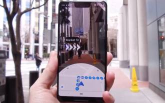
Google presented at its event, Google I/O, a novelty made for the Google Maps application that drew a lot of attention. The giant brought yet another innovation to mobile navigation apps, augmented reality! But don't get too carried away, because this feature was made only for those who are moving around on foot.
The Google Maps AR feature works using the phone's rear camera, so the person points to the streets and sees arrows indicating the direction they should go to reach their destination. Much better than seeing a blue dot moving around on the map, no? In addition, the map appears just below the camera image showing a summary of the route with dotted lines, with the estimated time to finish the route and the establishments around it.
- Google Maps announces new functionality [SUSTAINABILITY]
- Google Maps receives update for augmented reality games
This feature, for now, unfortunately, is exclusive to Google's smartphone, the Pixel. Also, it is not available for use in any region. For now, the feature is only available in some of the "major" cities in the world, such as San Francisco, Paris and London. Google also warns that the function will only work outdoors, in areas where it has "recently published" Street View and during the day only (due to the difficulty of detecting objects in an environment with lower light levels).
Fonte: Android Authority